Tuesday, March 31, 2009

Kazakhstan


Kazakhstan 200 Tenge UNC
Obverse: The images are vertical. In the center of the note is the Astan-Baiterek monument. In the middle of the banknote a fragment of music of the Kazakhstan National Anthem is printed in white on blue, brown and green stripes. Over the fragment of music is the white outline of the value numeral. To the left of the monument the Kazakhstan National Emblem is printed in green. The Kazakhstan National Flag is on the top right of the note. On the lower half of the note is an open hand. The face value, in Kazakh script, is shown vertically in the lower right corner. The name of the issuing bank, in the Kazakh language, is under the Kazakhstan National Anthem. Beneath the bank’s name is an inscription in Kazakh stating that counterfeiting banknotes is against the law.

Reverse: The images are horizontal. The main image is an outline map of Kazakhstan. In the foreground is the building of the RK Transport and Communication Ministry and a winged snow leopard on the bridge over the river Ishim in the capital Astana. In the background is the building of the RK Ministry of Defense and the steppes. The value numeral is shown both on the lower left corner and upper right corner. The face value, in Russian script, is shown in the middle of the lower half of the note. The name of the issuing bank, in the Kazakh language, and the bank’s logo are in the middle of the upper half of the note. In the top left corner, on the white area, there is an inscription in Russian stating that counterfeiting banknotes is against the law.
Information Obtained from National Bank of Kazakhstan


Bayterek, a symbol of the new Astana.
Bayterek (Kazakh: Бəйтерек, "tall poplar [tree]"), is a monument and observation tower in Astana, the capital of Kazakhstan. A tourist attaction popular with foreign visitors and native Kazakhstanis alike, it is a common symbol of the city and itself in turn symbolizes Astana's new status as the capital of Kazakhstan
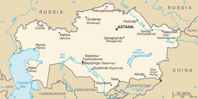
Map of Kazakhstan

Information and Image Obtained From Wikipedia, the free encyclopedia

China


China 10 Yuan 1980 G
Front: An old and young man on the front, Elder Han and Youthful Mongolian
Back: Mt. Everest
Mount Everest north face from Rongbuk in Tibet

Mount Everest, also called Sagarmatha (Nepali: सगरमाथा meaning Head of the Sky) or Chomolungma, Qomolangma or Zhumulangma (in Chinese: 珠穆朗玛峰 Zhūmùlǎngmǎ Fēng) is the highest mountain on Earth, as measured by the height above sea level of its summit, 8,848 metres (29,029 ft). The mountain, which is part of the Himalaya range in High Asia, is located on the border between Sagarmatha Zone, Nepal, and Tibet, China. In 1856, the Great Trigonometric Survey of India established the first published height of Everest at 29,002 ft (8,840 m), although at the time Everest was known as Peak XV. In 1865, Everest was given its official English name by the Royal Geographical Society upon recommendation of Andrew Waugh, the British Surveyor General of India at the time. Waugh was unable to propose an established local name because Nepal and Tibet were closed to foreigners at the time, although Chomolungma had been in common use by Tibetans for centuries.
Information and Image Obtained From Wikipedia, the free encyclopedia

China


China 5 Wu jiao 1980 UNC
Front: A Miao girl from Guizhou, Yunnan, Hunan, and Sichuan Provinces on the left; a Zhuang girl from Guangxi Zhuang Autonomous Region and Yunnan on the right
Back: National Emblem

China


China 1 Yuan 1980 UNC
Front: A Yao woman on the left, and a Dong woman on the right.
Back: The Great Wall of China
Photograph of the Great Wall in 1907 Read more

Burundi


Burundi 10 Francs 1997 UNC
Front: Map of Burundi, Coat of Arms

Guyana


Guyana $5 1992 UNC
Front:Kaieteur fall
Back:Sugar cane harvesting, Large crane conveyor

Ghana

Map of Ghana
Image Obtained From Wikipedia, the free encyclopedia


Ghana 1000 Cedis 2002 UNC
Front: Coat of Arm, Diamond
Back: Coacoa Harvesting

Monday, March 30, 2009

Cambodia, Preah Vihear Temple - UNESCO World Heritage Site

Image Obtained from cambodia.org


Cambodia 2000 Riels 2007 UNC
Front: Preah Vihear Temple
Back: Women Harvesting

Sunday, March 29, 2009

Cambodia, Angkor Wat - UNESCO World Heritage Site

Image Obtained From By JRodrigues on Flickr
Cambodia 2000 Riels 1995 UNC
Front: Fishing on the great lake "Tonle Sap". The frieze around the note is characteristic of the decorative art found on the Banteay Srei Temple.
Back: The rear view of Angkor Wat

Friday, March 27, 2009

Cambodia, Bayon temple, Angkor Thom


Cambodia 1000 Riels 2005 UNC
Front: Sculpture art of Banteay Srei temple printed in silver ink; Sculpture of naga serpent; Victory Gate at Angkor Thom
Back: Port of Sihanoukville.
Sihanoukville (Krong Preah Sihanouk), also known as Kampong Som, is a port city in southern Cambodia on the Gulf of Thailand and is a growing Cambodian urban center. The city is named after King Father Norodom Sihanouk and grew up around the construction of Sihanoukville Port. Construction on the port began in June 1955 and it was the only deep water port in Cambodia.

Bayon temple, Angkor Thom

Angkor Thom was the last and most enduring capital city of the Khmer empire. It was established in the late twelfth century by king Jayavarman VII. It covers an area of 9 km², within which are located several monuments from earlier eras as well as those established by Jayavarman and his successors. At the centre of the city is Jayavarman's state temple, the Bayon, with the other major sites clustered around the Victory Square immediately to the north.

Information and Image Obtained From Wikipedia, the free encyclopedia

Cambodia, Angkor Wat


Cambodia 1000 Riels 1992 UNC
Front: Angkor Wat
Back: Fishing

Cambodia, Angkor Wat


Cambodia 500 Riels 1991 UNC
Front: Angkor Wat, Coat of Arm
Back: Farmers on Tractor

Cambodia, Bayon sculpture


Cambodia 200 Riels 1995 UNC
Front: Irrigation sluice gates
Back: Bayon sculpture


Cambodia 200 Riels 1992 UNC
Front: Irrigation sluice gates
Back: Bayon sculpture

Cambodia, Independence Monument


The Independence Monument (Vimean Ekareach) in Phnom Penh, capital of Cambodia, was built in 1958 following the country's independence from France. It stands on the intersection of Norodom Boulevard and Sihanouk Boulevard in the centre of the city. It is in the form of a lotus-shaped stupa, of the style seen at the great Khmer temple at Angkor Wat and other Khmer historical sites. The monument was designed by the influential Cambodian modern architect Vann Molyvann.

During national celebrations -- most notably, Independence Day -- the monument is the center of activity. A ceremonial flame on the interior pedestal is often lit by a royal or high official on these occasions, and floral tributes line the stairs. Most of the year, however, the monument is visited by photo-taking tourists and locals looking for some quiet conversation
Information and Image Obtained From Wikipedia, the free encyclopedia


Cambodia 100 Riels 1998 UNC
Front: Independence Monument with a stone lion standing to its left side.
Back: Tapping Rubber Trees

Cambodia, Prasat Preah Vihear Temple

On July 8, 2008, the World Heritage Committee decided to add Prasat Preah Vihear, along with 26 other sites, to the World Heritage Site list, despite several protests from Thailand

Construction of the first temple on the site began in the early 9th century; both then and in the following centuries it was dedicated to the Hindu god Shiva in his manifestations as the mountain gods Sikharesvara and Bhadresvara. The earliest surviving parts of the temple, however, date from the Koh Ker period in the early 10th century, when the empire's capital was at the city of that name. Today, elements of the Banteay Srei style of the late 10th century can be seen, but most of the temple was constructed during the reigns of the Khmer kings Suryavarman I (1002 -1050) and Suryavarman II (1113 -1150). An inscription found at the temple provides a detailed account of Suryavarman II studying sacred rituals, celebrating religious festivals and making gifts, including white parasols, golden bowls and elephants, to his spiritual advisor, the aged Brahman Divakarapandita. The Brahman himself took an interest in the temple, according to the inscription, donating to it a golden statue of a dancing Shiva.[citation needed] In the wake of the decline of Hinduism in the region the site was converted to use by Buddhists.
Information Obtained From Wikipedia, the free encyclopedia


Cambodia 100 Riels 1972
Front: Prasat Preah Vihear Temple and Rising sun
Back: Aerial view of Prasat Preah Vihear Temple


Name: Temple of Preah Vihear
Creator: Suryavarman I and Suryavarman II
Date built: 11th & 12th Centuries CE
Primary deity: Shiva
Architecture: Banteay Srei style and others
Location: Preah Vihear Province, Cambodia


Plan of Prasat Preah Vihear.
Image Obtained From Wikipedia, the free encyclopedia

Cambodia, Angkor Wat

Cambodia 50 Riels 1956-1972
Front: Fishnet fishing on Lake Tonle Sap
Back: Angkor Wat
Image Obtained From Wikipedia, the free encyclopedia

Thursday, March 26, 2009

Cambodia, Bayon stone head, Angkor Wat


Cambodia 50 Riels 1979 UNC
Front: Bayon stone head
Back: Angkor Wat


Face towers of the Bayon represent the king as the Bodhisattva Lokesvara. Information and Image Obtained From Wikipedia, the free encyclopedia

Cambodia


Cambodia 20 Riels 1979 UNC
Front: Coat of Arm
Back: Water Buffalos Logging Scene
Horn differences between Cape buffalo (above) and Asian water buffalo (below)

Adult water buffalo range in size from 300 kg to 600 kg for the domestic types (the wild animals are considerably larger). River buffalo are usually black and have long curled horns, where as swamp buffalo can be black or white, or both, with gently curved horns.
General parameter of water buffalo. Standing 5- 6.2 feet (1.5 to 1.9 meters) tall at the shoulder, Size of head body up to 8 to 9 feet (2.4 to 2.7 m, Size of tail: 2 to 3.3 feet (60 to 100 cm), Weight up to 1500 to 2650 lbs (700 to 1200 kg)

Wild water buffalo are formidable mammals with sparse gray- black coats. Males carry enormous backward- curving, crescent- shaped horns stretching close to 5 feet (1.5 meters) long with deep ridges on their surface. Female are smaller in sizes and weight but they also having horns, although they are smaller.

There are differences between swamp buffalo and river buffalo. Swamp- type buffalo have swept- back horns and are native to the eastern half of Asia from India to Taiwan. All are similar in general appearance. River- type buffalo generally have curved horns and are native to the western half of Asia.
Information and Image Obtained From Wikipedia, the free encyclopedia
Related Posts with Thumbnails